Показват се публикациите с етикет highway. Показване на всички публикации

вторник, 27 септември 2016 г.

Crete - Chasing the Minoans - part one - Piraeus


The story I'm going to tell you, dear Reader, takes place in the long past (or not so much) 2009.

The month is September, the destination - Crete. Why Crete? Because I am the person who drags people around to excavations - stones, stones everywhere, walls around 20 centimeters tall and things like that. And no, I'm not an archaeologist. I am a culturologist (but that is subject of another discussion and it has nothing to do with travelogues. Besides, it wasn't in the itinerary in 2009). Back to the point - we're going to Crete.

This travelogue is a translation from the original Bulgarian text I wrote for the site patepis.com. I'm writing it in case you wonder why it differs from my previous works - this is a story that happened BEFORE I became a photographer. I was 17 then. 


The original story (published in Bulgarian) can be found here:

http://patepis.com/?p=68117


To be honest, at that time Crete seemed to me as exotic as Bora Bora. And generally as far away from home as it, for that matter... So we start wondering how to get there (to Crete, I mean, not to Bora Bora) - 2000 kilometers are 2000 kilometers everywhere.

My father plays the adamant - "I'm not going anywhere without my horse!“
– so things become clear - there will be driving. Which means HE will drive because neither me not my mother has a driver's license… Still, Crete is an island i.e. surrounded by water so we somehow cannot swim our way to it… Hence we're gonna use the most exotic option - namely - the ferry.

No problem in that. We hit the road a day earlier (because none of use is particularly fond of getting up at 4 a.m. so that we make it for the ferry), we sleep in Gotse Delchev (a town near the Greek border) and we cross the border with the crack of dawn and around 9 a.m we're down the road after Exohi (the Greek village that's given the name to the border check point.)


О tax, O toll – how to be mistaken for a Greek without knowing the language…


There are no vignettes in Greece. But each 50 kilometers or so you have to pay a toll tax. Money can vary depending on the distance - somewhere you'll pay 1 euro, at other places tax rises to 2 or 3 euro. The whole journey costs around 30 euro (now it's more because there are toll stations down Egnatia - the highway that connects Thessaloníki and Kavala, while in 2009 the highway was brand new and there were none). What's interesting, however, is not the pricing but the conversations we have with the people at the toll stations…

We stop at the first one. There is a car in front of us - they drive on, we count the money for the tax.

Kalimera! (Good morning/ Good day in Greek) – says the lady from the booth
Kalimera! – I respond from the back seat – I've bought a Greek textbook less than two weeks ago and I'm not afraid to use it.
Evharisto! – she thanks us.
Parakalo! (you're welcome) – I answer again because my father doesn't.
Kalo taksidi! (have a nice trip) – she says, hands us the receipt and we move further.
I'm very pleased with the short conversation and I don't even think out why, actually, she addressed us in Greek while our car is with foreign registration plates. Same thing happens at the other toll stations - around the forth my father learns the words and starts answering the cashiers himself.

Somewhere just before Athens one lady looks absolutely confused and babbles something in Greek from which I make out only the word 'lepta'. While I'm figuring out that she she doesn't have enough money for the change and asks us if we have some cents (lepta means coins in Greek), we have sorted it out in English. Across (in the booth) we hear laughter and the woman hands us the change with a huge smile wishes us a nice trip, in English, this time.

While we drive on, we laugh our heads off, because here (and in the previous toll stations) they obviously took us for natives - for Greeks… While we joke about having some Byzantine descent we enter the outskirts of Athens…

A surprise is waiting for us there - a traffic jam so big that my father starts oozing saliva as if he's rabid. How could he not - a highway with 4 or 5 lanes in each direction and each and every one is jammed with cars as far as the eye could see. My father really wants to get off the highway and drive along the narrower streets of Athens so there is a big battle in keeping him in the middle of the highway (if he gets off it, we'll roam the streets of Athens forever). The time is around 4.30 p.m., the ferry leaves at 9 (if we actually buy tickets for it). So we have plenty of time…

We sit and wait in the traffic jam when the side window of the car next to us opens and a man starts shouting:

Apo pia to Markopulo? – he repeats but he's chosen the wrong car. My mother shrugs to show without words that she doesn't understand him. He for some reason decides that we didn't hear him and repeats the phrase. I start shuffling the pages of the textbook and it dawns on me…
Den xero elinika! (I don't speak Greek) - I yell a few times out of the window to make him hear me. He does on the third time and starts laughing his head off - the driver literally fell of the steering wheel.

The car passes by and a few hundred meters we find out what's so funny.  There is a road sign for that Markopulo, which turns out to be a town near Athens where they make the famous Retsina wine. The guy took us for natives and decided to ask - since the cars were side by side in the traffic jam – but he chose the wrong people.


The Greek alphabet - or how to read your road signs…


In case you don't know, my dear Reader, Greeks write in Greek. Which has nothing to do with ANY other language in the world. Their alphabet looks a bit like the Bulgarian one but similarities end here. Most road signs in Greece are... in Greek. So far, so good, but even the signs that should be in English are actually in Greek.

We have to take the ferry so we need Piraeus - the port of  Athens. Actually Piraeus was once an independent city but the megalopolis grew and now they are one whole. So we're looking for a road sign for Piraeus but we see nothing. Absolutely nothing. The roadsigns on Greek highways are huge but the names don't ring any bells…

At some point an alien name appears. It says PEIRAIAS. Great but what's this? It should be in English but it doesn't sound English. I feel as proud as if I've discovered America when I discover the reading rules of Greek (in that sacred textbook of mine). It turns out that the combination of the letters EI is read as I, and AI as Е. After I've broken the code it turns out that what I'm reading as PEIRAIAS, Greeks read as PIREAS. Eurica! So the sign is for Pireaus! We drive that way.


How to board a ferry - a few DON'Ts


After a few minutes' drive - again in that traffic jam, it was rush hour – we arrive at Piraeus. It turns out that it's not that easy to board a ship though - not like going to a Bulgarian port and jumping in the first boat you lay your eyes on. I thought, to be totally honest, that I'd see something resembling the Radezky ship ( very famous ship from the 19th century connected to Bulgarian history - now a tourist attraction), my father - of the ferry that goes from Thassos to Keramoti (or as he says 'bath tub'). My mother smiles but keeps silent.

The port of Piraeus is HUGE - to find your ship you have to find your gate - and they are all coded - each destination has a letter code and depending on where you're going, you can end up at either side of the port. We find our gate - for Crete - and my jaw drops.

Ships, ships everywhere!!!


Another ship waiting for passengers - for Crete too, probably - at the same gate. Shot taken from the top deck of our ship. Around the time I took the image, most ships at this gate are already gone and that's why it looks so empty (and you can see these great reflections). Otherwise ships are jammed like sardines.


They are so  many and so big that it looks a bit scary! Which one is our ship, though? We get in and we stay at the gate - i.e. at the parking across the parked ships. There are no road signs so my father parks as he pleases and my mother gets off to buy tickets. Two minutes later a truck appears from somewhere and starts circling us. The driver is out of the window to see the idiot who plays a parking bollard.

Less than two minutes later another truck appears and goes around from the other side. I notice that drivers hand in some really long sheets of paper to a man ten meters away and point angry in our direction. The man in police uniform notices our foreign registration plate - which means bushmen who are foreign to all kinds of ports - and send out his younger colleague to talk to us, to save face before the foreign tourists. After a few torturous minutes we sort out that we don't speak Greek and she speaks very little English so we use very simplified and accented English garnished with a lot of gestures to understand that we are a traffic problem, where we're standing.

Another ferry - not ours - for Crete. Notice how big these ships are - you can see a few trucks lining in to get inside to add scale to the whole image. I must point out that these ships are small compared to the big cruse 'monsters' which wait for passengers at the other end of Piraeus - they have 30+ decks. For comparison - our ship has only 8 of which 2 or 3 are garage decks. Embarkation of cars and trucks is a complicated and highly responsible task. The guy with the radio has a MAP of the cargo - which means how many vehicles of which type can be put where. This map is strictly used each time the ship stops at a port. During the voyage, the garage is locked and the vehicles are chained to the floor - you can get when the ship arrives by the noise you can hear from below (where the garage decks are) - you can hear clinking of chains - that means they free the cars and disembarkation begins soon. On this picture you can see the entrance for cars and trucks.

My father moves the car and we park next to the altar of Agios Nikolaos (St. Nicolas) - after all, we are at a port, it's normal to have a temple of the guardian of sailors and fishermen so I shoot a quick wordless prayer at the saint, you never know what the vessel would be embarking… My mother gets back with the tickets - three for us, one for the car - and we start wondering which one is our ship. A piece of cake for me. The name of one of the ships nearby is KRITI so I decide that it should be going to Crete. How many ships can be leaving at the same time for that island??? My mother goes there.

The guy with the radio looks at the tickets and then tells her that she has to board another ship, not this one. It turns out that apart from our names, the name of the ship is also on the ticket. But who would bother to read that…

A bit of information about the ship


After we board the ship and we're given a cabin - after all the drive from Gotse Delchev is a long one and we'll have to get up very early the next morning to drive again, we have to sleep somewhere.

Most Bulgarians imagine a ship like a платноходка or in my case - as the Radezky ship I told you about earlier. Ferries, however (here I mean the big ones for long distances not those small for Thassos) are much bigger and way different.

Our ship boasts with 8 decks - 2 or 3 are for the garage (cars and trucks are parked down there like a puzzle and ordered around by that guy with the radio - each ship has one like him), the rest are filled with cabins. Each deck has a MAP on which you can see where you are and which cabin numbers are around - like in a hotel.

To us (my father and me, because my mother knows where she's going) its' a jaw-dropper from the moment we get off the car. For the record, they give us parking advice (cars should be parked less than 20 centimeters away from one another so that they don't move around while we're sailing) in Bulgarian. I guess someone in the garage has worked on the Keramoti-Thassos ferry (where most of the tourists come from Bulgaria) before he came to Piraeus.

From the garage we take an ELEVATOR which takes us to reception deck - deck 7. There we meet a  who escorts us to our cabin (after we got the card that opens it at reception) and shows us how to put down the beds and how to operate the air conditioner.

Have you ever watched the TV series 'Das Traumschiff, dear Reader?

Well, this ship (the ferry) is bigger (more decks) and newer (way newer)! On reception deck you can find shops, even a параклис and a few restaurants. They open half an hour before departure and close around 11 p.m. (when you arrive at 5 a.m., that's normal).

The top deck is for those who decided that they don't need a cabin - there are a lot of benches and the Giros (Greek style )and drink booth works 24/7. On board you can find a bit for each taste.

The top deck is crowded, mostly with Greeks who don't share in our nostalgia towards the continent - for most of them, taking the ferry is like taking the bus. They surf the net on their laptops (that was in the ancient times where smart phones were not yet invented), talk on the phone or just sleep and wait for the ship to go. The funniest thing of all is that they are not in the least impressed of the fact that they are moving on water instead of land. But as my father says, Greeks are born on their ships…

Our cabin is equipped as a hotel room - we have towels, glasses and all other things that a tired traveler might need. The fact that we are no a ship shows in two things - the narrow space (we took a windowless cabin, we'll be traveling at night) and the life jackets in the wardrobe. The air conditioner works non-stop and maintains a relatively low temperature - you need some kind of ventilation - but the people are kind and they've left us some blankets.


Inside the cabin, apart from the 4 beds, a TV and a bathroom you can find a wardrobe. Full of life jackets. The stairs are used to get on the upper beds. 

We get a drink - after all that adventure, who would say 'no' to a drink - and then we get out to say 'Goodbye' to the continent and to set off for the far away Cretan land.
Piraeus at departure - the ship has already started and I take a picture of the land. The ship is led by a small boat of the coast guard. They are the boss of the port in some way - they say which ship leaves when and without them, no one can move around the port.
In the next post you'll find out why people (the Dutch in particular) invented Booking.com. 

събота, 20 февруари 2016 г.

Corinth Canal - part 1 - or why light matters?

I've been thinking a lot about what to write next in the Travelogues section and I kept coming up with one and the same idea - Corinth. 

Read part 2 here


Here we are - next topic is Corinth Canal or Korinthos Isthmos (or if we want to be exact - Ισθμός της Κορίνθου in Greek).

Where is that? 
The most logical question here is to ask - where is that on the map? If you are not interested in geography, history and you don't live on the Balkans, you probably have no idea. The answer is simple and it is GREECE. 
Image taken from http://www.worldatlas.com/webimage/countrys/europe/corinth.htm

So far so good, but where in Greece? After all, it's not that a small country. I will not keep you waiting - it's between Peloponnese and mainland Greece. You can see it on the map below:
Image taken from http://www.worldatlas.com/webimage/countrys/europe/corinth.htm
In case you don't know - Peloponnese is the biggest peninsula in Greece and the south-most part of mainland Greece. Don't worry - there will be a post about Peloponnese as a whole later on. 
Corinth Canal is what separates the peninsula from the rest of Greece. 

A bit of history. How, why and when was the canal created?
Before I went to Corinth, I thought that the canal was made in ancient times. Turned out that in ancient times Corinth was one of the wealthiest towns in Greece but not because of the canal - it was the lack of it that made people so wealthy. Corinth had two harbors - one of each side of the Isthmus - and ships used to be dragged from one to the other. Of course, Corinthians charged travelers for the service - even if you don't want to transport the whole ship across the land, luggage still had to be carried to the other harbor. The alternative was going around the island of Kythira and facing the danger of getting in one of it's notorious currents and storms. Most ships didn't want to risk that much. 
Nero's plan for the canal
Image taken from https://en.wikipedia.org
The whole process was so uncomfortable that even at ancient times emperors such as Julius Caesar, Caligula and Nero planned to dig a canal to end the misery.  Problem was that none of them lived long enough to do that. In later centuries plans were forgotten and after the Ottoman empire came in the 15th century - people had bigger problems... 
Things changed in the 19th century when Greece got its independence. The Greek government asked a French company in the 1830s to dig it but the price - 40 million gold franks - was too high so the project was abandoned for a couple of decades. Then, in the 1880s another French company took the project. Before it was built, several companies and entrepreneurs got bankrupt before it was finally opened in 1893. 
The canal during construction in 1882
Image taken from http://corinthianmatters.com/2013/01/18/historic-photos-of-the-isthmus/
Still, there were some problems.
Problem 1 - the canal was too narrow which meant that big modern ships, which were just evolving back then, could not use it. Narrowness meant that there was a lot of wind in the canal itself. So many ships avoided it anyway. 
The canal during construction in 1884
Image taken from https://corinthianmatters.files.wordpress.com/2013/01/isthmus-1884_551573_536651073012278_1728426558_n.jpg
Problem 2 - the different tide time of the two seas on both sides of the canal which made it difficult to navigate and caused dangerous currents inside it. 
Problem 3 - Greece is a highly seismic region. The canal location is even more so. Besides - the rocks are of sedimentary nature and thus - are quite unstable. That meant a lot of landslides.
Things didn't get better in the 20th century either - WWI and WWII did their job well to slow the traffic down to a trickle. Still, the canal is a wonder of the engineering mind and a spectacular place to visit. 
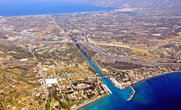
The canal as seen from above
Image taken from http://www.sailingissues.com/corinth-canal-diolkos.html
How to get there?
Here are a few ways:
Route 1 - say you are traveling by car - you'll need the highway that goes to Athens first. When you get to Athens the highway will fork - one part goes down to the gates at Piraeus and the other goes for Corinth. You need Corinth. The view from that part of the highway is really nice because you drive along the coast. Just follow the big green roadsigns (which will show the nearest town - in our case Corinth). The distance between Corinth and Athens is roughly 80 kilometers.
Route 2 - get on a plane for Athens. When you get at Venizelos airport (aka. Athens' airport) you get a rent-a-car and follow the instructions from Route 1.

What we did is to drive all the way from Sofia to Athens - which is 800 something kilometers (thank God for Greek highways!!!) and then to Corinth in one day (thank God the driver LOVES to drive!!!). 

How to find the canal???
If you have seen the pictures on the net (as I have) - you probably imagine a narrow and shallow little canal in the middle of a meadow. Truth is very far from that. The main traffic from mainland Greece to Peloponnese goes ABOVE it (I mean literally above it!!!) and you can see that it is DEEEEEP. REALLY DEEP. 

Once you get near the town of Corinth, there would be a big (you can't miss it, it is several meters wide) green road sign reading Korinthos Isthmos (in Greek and Latin alphabet). You take that turn RIGHT (if you are coming from Athens as we did) and then follow the main road that goes to Peloponnese. You need the main road that says Tripoli (the next bi town along the highway) or Nafplion (the nearest town in Peloponnese). There are NO other roadsigns indicating where the canal is once you enter Corinth. Guess it is because everybody knows it and if you ask, they will be happy to show it to you. 

Check out Google Streetview !!!!! to see where exactly you have to turn (LEFT, I think, if you are coming from Athens) for the parking and the viewpoint. There would be NO sign - if you are driving along the canal already, you have missed it. There is a big municipal one that is free of charge and you can buy souvenirs as well. There are no tickets for the view - after all - it is on the main road.  

What to do?
As I said above, the main traffic in and out Peloponnese goes ABOVE the deepest part of the canal (where all the pictures are taken). The bridge that houses the main road also houses the viewing platforms - that would allow you to peer around 70 meters down to the bottom of the canal and take a few photos of it. 
Problem 1 - when we went there one of the viewing platforms on the left/right hand side of the road (depends on the direction you are going) and which hosts the iconic view of the canal was closed. 
Problem 2 - The viewing platforms are NOT part of the bridge - they are metal constructions that are attached to the concrete base of the road - so all the vibrations from the traffic on the road are felt on the bridge. Trust me, if you watch the abyss below - that's not fun. 
What you can see from the other side of the bridge - photo from the evening

Problem 3 - The platforms are fairly narrow so if you want to take a picture of yourself AND the canal WITHOUT having the railing and the platform in shot, you won't succeed. The other option is to hang on the main road and risk getting run over.
Don't get too excited  that picture is from the next day. That is the viewing platform

Problem 4 - The road is REALLY busy - almost every minute you have a truck or a bus on it - so you cannot (even if you are such an idiot) stand in the middle of the road to get a better vantage point. 

The canal
When I saw the pictures of the canal I thought it is deep but when I was it in real life - my jaw dropped. 
I'd be honest - I'm afraid of heights. Well, I don't faint or something, but I don't like being that high. High buildings are OK, as long as I don't have to go on a balcony (which is another story). But walking over an around 70 meter abyss... is quite another matter. As I said, my jaw dropped!!!
The view is A-M-A-Z-I-N-G!!!
What I saw at 6.30 pm

Problem 5 - By the time we got there (after a 10-hour drive from Sofia) it was already past 6 pm. That is not much of a problem but light is all about the view of the place. Main problem lies in the depth of the thing - the less light you get, the darker the bottom is. Water is only 8 meters deep so it is a lovely hue of blue when it is lit. 
In my case - it was dark as hell and I was furious. I've been dreaming about going there for a long time so I didn't want to miss it. The only resolution was to get back the next day when the light was right - which meant at midday when the light falls directly from above.  That was despite the fact that we had to visit Mycenae and a few other archaeological sites. I hoped that I would be able to take the picture I want.

About that - in a follow-up post! 


събота, 3 октомври 2015 г.

Transfagarasan when it rains??? Only if you are a fan of the hard driving routes! part 1


This particular post would describe a disappointment of mine. I watched the Top Gear episode about the Transfagarasan highway and nagged to go there. So we went but we had missed something - the weather was not in our favor. It rained all the way and to make matters worse - there was a 'nice' fog that combined with the torrential rain made taking decent pictures impossible... You'll see what I mean later on. 

But first things first.

In case you want to skip ahead to the story: 
Part 2

Part 3

Here is the video I made - just to give you an impression of what I am talking about:


What is Transfagarasan?

You, especially if you are not Romanian, probably have no idea that the place exists. So the logical question is - what on Earth is this place??? Ok, it is in the Carpathian mountains and obviously is a mountain pass. Nothing comes to mind? Ok, let me show you a map:

Image taken from mitteleuropa.x10.mx

 In case you don't know where Romania is - I'll have to ask you to consult with Wikipedia. If you din't get much of the map - here we go - the big brown thing in the middle is the Carpathian mountains - the longest mountain in Romania (I think it is the highest as well). The red rectangle shows what I am talking about - where is the Transgarasan highway.

Here is a road map of Romania to get an impression of their road system: 
Image taken from mitteleuropa.x10.mx

 To be even more precise - here is a map of the mountain pass itself: 
Image taken from https://guideandtravel.wordpress.com/tag/dn7c/


The road is known in Romania as National Road 7C - that means it is a wide road in good condition that is the shortcut from Curtea de Arges (down on the map) and Sibiu (up left). The name comes from the mountain of  Fagaras and means "through Fagaras". There is also a town with the same name (up right on the map). 


Here is a quote from Wikipedia explaining things in short: 
The Transfăgărășan (trans (over, across) + Făgăraș) or DN7C is a mountain paved road crossing the southern section of the Carpathian Mountains. It has national-road ranking and it is the second-highest paved road in Romania after Transalpina. The road starts near the village of Bascov, located near the city of Pitesti, ending on the crossroad between DN1 and Sibiu. Also known as Ceaușescu's Folly, it was built as a strategic military route that stretches 90 km with twists and turns that run north to south across the tallest sections of the Southern Carpathians, between the highest peaks in the country, Moldoveanu, and the second highest, Negoiu. The road connects the historic regions of Transylvania and Wallachia, and the cities of Sibiu and Pitești.

History

I'll try to be short here - the road is called Ceaușescu's Folly with a good reason. See, the dictator decided that he should have a quick access between Transylvania and Wallachia which is not along a river valley (so more difficult to attack - don't ask - military strategy and it's too long to explain) AND  he decided to do something grander than the longer and higher Transalpina (see map below). 


Image taken from https://guideandtravel.wordpress.com/tag/dn7c/
So in 1970 the guy ordered the army to build his masterpiece. Problem 1 - they were on a schedule (quite tight one, mind you). Problem 2 - the terrain was very difficult to civilize and there were a lot of rocks to be blown up in order for the road to be built. Problem 3 -  Ceaușescu, as any other dictator, for that matter, was paranoid against Soviet invasion in Romania so safety measures were not a big concern, neither were casualties. Wikipedia will give us the details: 
Built mainly by military forces, the road had both a high financial and human cost. Work was carried out in an alpine climate, at an elevation of 2000 meters, using junior military personnel who were untrained in blasting techniques. Many non-commissioned officers (NCOs), foremen, and soldiers died due to hazardous working conditions. Roughly six million kilograms of dynamite were used on the northern face, and official records state that about 40 soldiers lost their lives in building accidents. These numbers are likely to be under–estimations due to Communist propaganda touting "greatest care for men."The government could not admit the loss of so many lives caused by the disregard for labor protection rules.To this day, the exact number of lives lost is not known, yet survivors estimate the number to be in the hundreds.
As you can see for yourself,  Ceaușescu was not a very likable guy - probably one of the reasons he didn't die of old age in his bed (which, however, is not the topic of my post). 


The Transfăgărășan highway

OK, here we come to the real thing - the highway itself. There are a few things to sort out first. 

The name - I will keep spelling it without the diacritics (you know, those strange looking things above and below the letters in the name) because Romanian is full of them and I can't spell them all right. The actual pronunciation of the name is 'Transfagarashan' with a 'sh' sound even though throughout the post you will see it written (for convenience's sake) as Transfagarasan (with an s letter). 

The length - Wikipedia keeps saying that it is only 90 kilometers long but according to a road sign I took picture of while we were there - it is 152 kilometers. Don't get hysterical - only 50 or so of those are like the picture in the heading - serpentines and one curve ending in another. About that I'll talk later. Here is a picture of the road sign itself:
Here the road sign says that the pass is open

The speed limit - in the video clip I have posted below you'll get the impression that it is an easy and quick drive. Truth is that the advisable AVERAGE speed should NOT EXCEED 40 kilometers per hour. If you think you can drive at a higher speed - you can - the road is a wide one and in a quite good condition in most places. But I think the views and the curves as well as the elevation on more than 2000 meters will quickly discourage you if common sense doesn't. 

The duration of the journey - average duration is 4 to 5 hours depending on traffic, weather conditions and well, how long you will be staying at the viewpoints. It is a busy road and Romanians do use it. To the natives of Sibiu it is the shortest way to get to Pitesti (another big city on the other side of the mountain). Romanians tend to drive dangerously so be on the alert. 

The weather - on most pictures of the Transfagarasan you'll see nice warm sun and fluffy white clouds and/or blue sky. Don't get fooled by that - it is COLD and by saying cold, I mean cold. Unless you are a polar bear, temperatures between 5 and 10 degrees Celsius in September would be cold or at least, chilly. 

What to do BEFORE you go there? 

- Check the weather forecast - if you don't want to see what I saw (you'll see the pictures and the clip later in the post) check and double check the forecast for Curtea de Arges (on the one side of the mountain) and Sibiu (on the other). You'll thank me for that, trust me. If it shows rain/showers/ thunderstorm in ANY OF THE TWO just DO NOT go. Chances are that if it rains on either side of the mountain, it would rain in it, too.  It showed showers and we were rewarded by a torrential rain up there. Go in the rain ONLY if you have a long driving career and considerable amount of skills! 


- Check if the pass is open - since it is a popular tourist attraction in Romania, Transfagarasan has its own website and there you can see whether it is open or no. Here is the website: 
Transfagarasan is generally closed between October/November and April/May the next year. However they close the serpentines (the top 50 kilometers with the scenic curves) when the weather is bad and the moment the first snow falls because of avalanche danger. Each year the period varies, so do your homework.  

- Check the car systems AND THE BRAKES!!! - DON'T EVEN THINK OF GOING THERE IF THERE IS SOMETHING WRONG WITH THE CAR. Transfagarasan is one of the most dangerous roads in Europe and the most common cause for death is a problem in the brakes of the car or somewhere else. Most of the high curves are not fenced so there is nothing that would stop your fall down the 1000 meter abyss. It is a beautiful place but caution first. GO ONLY IF YOUR CAR IS 100% WORKING! 

- Think twice if your car is fit to do it - If you drive a sports car, even though Romanian roads are amazingly good, you should think twice before using it on the Transfagarasan highway - it will perform well but for that journey (personal opinion) you'll need something higher (such as an SUV or a high hedge-back) because the viewpoints are 20 to even 30 centimeters BELOW the level of the road. So if your car is flat on the road imagine what would happen if you try to pull over and enjoy the landscape. The level difference is due to the abundance of water up there - they did it as a drainage of some sort.

- Find a decent hotel -  There are a few very nice places along the road which are in the lower parts of the pass and have amazing view but since Romanians love them too, you should book a hotel first. Don't count on coming and finding something on the spur of the moment! Also BEWARE OF WEDDINGS! if you happen to be in the area on a Saturday you have a very high chance of encountering a wedding. That in itself is not a problem and even seeing the bride brings good luck but that also means that you'll be an intruder in the restaurant - it is their day so they don't want tourists around. Also weddings on the Balkans mean a lot (I really mean A LOT ) of noise - generally local music blasting your eardrums out up till 4 or 5 AM. So if there is a wedding in your hotel (which unfortunately, you can't know in advance), you'll probably have to eat somewhere else. 

Since it is quite a lengthy post - I'll tell you the story and show you the pictures in a follow-up :)